Monday, October 29, 2012

Sunset Over Gray Lodge Wildlife Area

It's beginning to be that time of year, when millions of ducks and geese return to winter in the Sacramento Valley.

Sunset over Gray Lodge
Gray Lodge State Wildlife Area is one of the main wildlife preserves in the Sacramento Valley. I happened to be there the day before the start of duck season this year, so much of the preserve was packed with hunters reading themselves for the hunt the next day.

I found a quiet spot far from the hunters to capture the beautiful sunset. Unfortunately, it wasn't far from the mosquitoes. Literal clouds of of mosquitoes rose from the shore of the wetlands every time I approached to take a picture, I had to keep in continual motion to avoid being devoured by the thirsty winged hordes. Stopping, even for a couple of seconds to change lenses, resulted in several bites.

There were 446 mosquitoes in this picture. I know because I counted them as I cloned them out of the image in Photoshop.
Still, it was a beautiful sunset and I managed to get a number of wonderful images, despite my bites. I just feel sorry for the camping hunters who had nowhere to run to to get away from the beasts.

Sunset over Gray Lodge


Tuesday, October 9, 2012

The Sacramento Skyline

One of the fascinating things about the Sacramento Skyline is how it's appearance changes as the light changes from sunset through dusk. Sacramento has a wonderful skyline, particularly as seen from the Sacramento River with the Tower Bridge, Old Sacramento, and the Delta King in the image.

I recently took this set of images - all from the same spot - as evening settled over the city. Click on each image to view a larger version.

Just before sunset
Just after sunset
As dusk settles over the city
Almost full night

Tuesday, October 2, 2012

Tower Bridge

Sorry that I've been away for awhile. For about a month I was just too busy to post, and for the last two weeks I was ill. Now I'm better and hopefully will be a little better about posting.

This week's images are some images I took of the Tower Bridge over the Sacramento River a couple of months ago.

The Tower Bridge is one of my favorite local landmarks, and I particularly like the contrast of color between the gold of the bridge and the blue of the sky. So for this shoot, I shot at dusk in order to get the deepest blue sky that I could.

Tower Bridge
Tower Bridge
Tower Bridge
Tower Bridge and Ziggurat Building

Monday, August 13, 2012

Tilting at Windmills

The main purpose of my flight down to the Sacramento River Delta was to shoot the wind farm in the Montezuma Hills from the air.

This wind farm has grown dramatically in the past few years and continues to grow, as the number of windmills under construction showed.

I had a blast flying a couple of hundred feet above the tops of the turbines on what turned out to be a perfect day for flying.


Monday, August 6, 2012

Aerial Shoot of the Sacramento Delta

I had the opportunity to do an aerial shoot in the Sacramento Delta a week or so ago, as you may have noticed from my recent posts. Here are a few more of the images I came back with.

The Town of Isleton
The Rio Vista Bridge
Panorama of the Antioch Bridge
The Antioch Bridge
Boats at Tinsley Island
The Delta and Mt. Diablo

Wednesday, August 1, 2012

The Making of Another Aerial Composite Image

Over the past few aerial flights I've been trying to perfect a technique that is part photographic technique and part Photoshop technique in order to take high resolution composite aerial photographs.

This is a particularly problematic thing to do because an airplane is always moving - most panoramic and composite images are made using a tripod firmly planted on the ground.

While it's true that I could use a helicopter to make such images, helicopter time costs at least twice what airplane time does.

My last post discusses making a 7 frame panoramic image. This post discusses making a high resolution square image rather than a panorama - using the same technique.

Here's the final image (a shot of a wind farm in the Sacramento River Delta, with Mt. Diablo in the background):
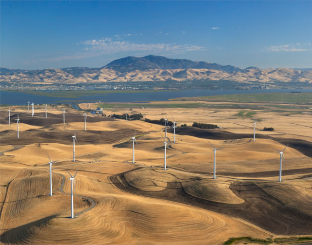
Click to view larger

As in the previous post, the image started by having the pilot make a tight right turn. In this case, we were flying slower (about 75 MPH) and I took 4 shots over a 4 second period - one frame per second. This gave me a much tighter stack of frames than in the previous shoot, and a much greater overlap between images - which I would need.


When you take photographs from different locations, it is impossible to perfectly line up both the foreground and the background elements of each image at the same time. You can prove this simply by looking at near and far objects through your left eye and then your right eye.

In my last post, I was able to get around this partly due to artful blending in Photoshop and partly because the difference in distance between the foreground and the background was not that great.

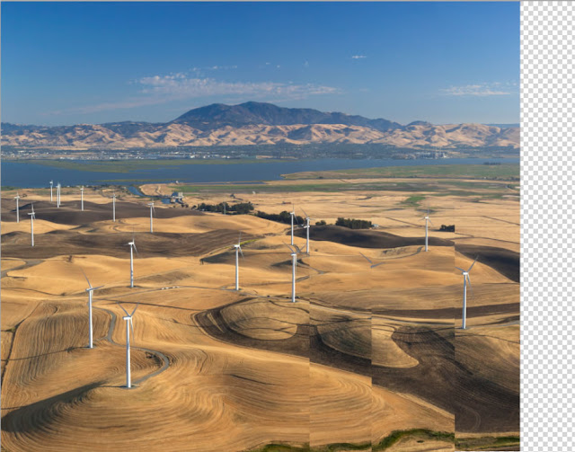
In this image, I had windmills literally only a few hundred feet away from the plane as well as a mountain 18 miles away. Even with four images, each taken only a second apart, there was no way to do a straight blend of the frames.

As result, I had to blend the foreground and background parts of the image separately in Photoshop:
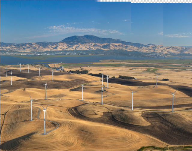
Foreground Blend
Background Blend
Because the background appears to move less than the foreground as you move, it blends into a smaller composite image than the foreground. To fix that, I re-sized the background blend to match the foreground and merged it on top of the foreground blend, lining up the images as much as possible. It helped that I had a stretch of water in the middle distance to use as a blend line:


The final image is 6700x5400 pixels - about 36 megapixels.


Tuesday, July 31, 2012

The Making of a 7 Frame Aerial Panorama

Lately, the Sacramento Delta has been in the news as a revival of variations the Peripheral Canal project are in the news.

I took the opportunity to do an aerial shoot of the Delta region. I'm still working on the hundreds of images I took that day, but wanted to share one particularly neat shot.

Sacramento River Delta (click to view larger)
This image is a 7 image stitched panorama, taken while flying 120 miles per hour (according to my GPS readings recorded on my phone). 

How did I do it? It started by having the pilot make a tight right turn. Then I fired off a frame about every seven seconds as we made the turn. The entire turn took (again, according to my GPS) about 50 seconds.


That was the easy part. Stitching the images in Photoshop was much more time consuming.

Since each of the images was taken from a slightly different location, the built in Panorama tools in Photoshop can't successful stitch together seven aerial images. So, I had to do it by hand. This didn't turn out to be terribly difficult; just time consuming.


A bit of careful and creative image blending created a seamless image measuring 17,441 x 3,583 pixels, or 58 x 15 inches at 300 dpi. And that's the advantage of a stitched panorama: the size of the image is limited only by your ability to successfully stitch images together. As a result, this image provides an unprecedented level of detail, as the image below demonstrates.


I'll have more images from that aerial shoot in the coming weeks.